How Good Science Influenced Public Policy to Protect a Critical Water Supply Resource
Influence of Groundwater Levels in the New Jersey Coastal Plain on NJDEP Water-Allocation Decisions
Presented by Rick Kropp, Glen Carleton, and Ovidiu Petriman
Location & Schedule
The New Jersey Infrastructure Bank Conference Room,
3131 Princeton Pike
Building 4, Suite 216
Lawrence Township, NJ 08648
8:30 - 9:00 am Refreshments and Networking
9:00 - 10:00 am Presentation & Discussion
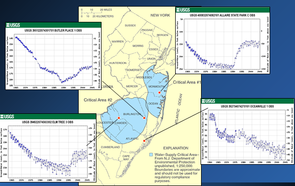
The USGS and NJDEP are teaming up to present a history of measuring water levels in the New Jersey Coastal Plain and how the data have been used to inform water allocation decisions. Every 5 years since 1973, the USGS and NJDEP have partnered in the mapping of water levels in the confined Coastal Plain aquifers of Middlesex, Mercer, Monmouth, Burlington, Ocean, Camden, Gloucester, Salem, Cumberland, Atlantic, and Cape May Counties.
Rick Kropp (USGS, formerly NJDEP Bureau of Water Allocation) will present a brief history of water-allocation decisions made in the 1980s in response to rapidly increasing withdrawals, dropping water levels, and the 1980-81 drought, including the creation of Critical Areas 1 and 2 and the construction of the Manasquan Reservoir and the Delran treatment plant and pipeline. Glen Carleton (USGS) will show the evolution of water levels in the major confined aquifers of the Coastal Plain, including the recovery of water levels in Critical Area 1 (~Middlesex/Monmouth Counties) and Critical Area 2 (~Camden/Gloucester Counties) in the 1990s and more recent water-level changes. Ovidiu Petriman (NJDEP, Bureau of Water Allocation and Well Permitting, Division of Water Supply and Geoscience) will make a short presentation on how the water-level data provided by the USGS Coastal Plain synoptics are used in the decision making process for the Water Allocation program and aids in short term and long range water supply planning efforts and policy development in the State of New Jersey.
Rick Kropp is the USGS NJ Water Science Center Director (2002-present) and was the Chief of the Bureau of Water Allocation from 1985 to 1996. Rick worked with NJ Assemblyman Robert Shinn to revise the Water Supply Management Act to allow the NJDEP to establish Water Supply Critical Areas 1 and 2. He was also responsible for the water supply planning that led to new surface water supplies including the Middlesex pipeline, the Manasquan reservoir and the Delran intake, which allowed for changes in water allocation permitting to require conjunctive use of groundwater and surface water supplies that subsequently led to recovery of groundwater levels in over-allocated aquifers of the Coastal Plain.
Glen Carleton is a hydrologist with the USGS and has worked on NJ Coastal Plain Synoptics every 5 years beginning in 1988. In addition to having driven all over 11 Counties measuring hundreds of wells, he has interpreted the water-level data and used the data to calibrate groundwater flow models in the Coastal Plain.
Ovidiu Petriman is a geologist with the NJDEP, has over 32 yeas of experience working as a geologist, with the last 15 years (since 2003) working in the Water Allocation program that regulates the use of water resources in New Jersey, including the water allocated from confined aquifers in the Coastal Plain.
Please note that this talk is eligible for 1 AICP CM Credit self-reporting and 1 NJ PE Credit self-reporting
