| New Jersey Section of American Water Resources Association (NJ-AWRA) |

The Aquaduct - Summer 2011
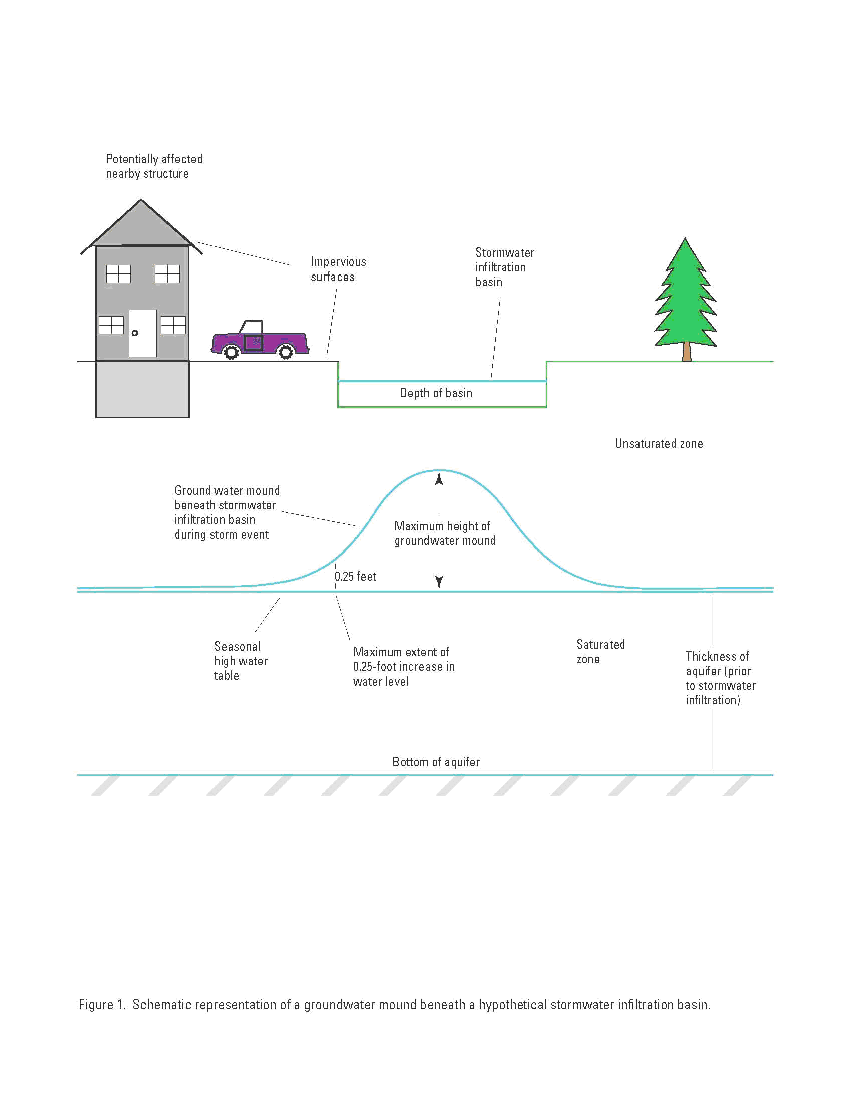
Simulation of Groundwater Mounding Beneath Hypothetical Stormwater Infiltration Basins: An Abstract
By Glen B. Carleton,
Groundwater mounding occurs beneath stormwater management structures designed to infiltrate stormwater runoff (Figure 1). Concentrating recharge in a small area can cause groundwater mounding that affects nearby structures. Maximum heights of simulated groundwater mounds beneath stormwater infiltration structures are the most sensitive to (show the greatest change with changes to) soil permeability. The maximum height of the groundwater mound is higher when values of soil permeability, aquifer thickness, or specific yield are decreased or when basin depth is increased or the basin shape is square (and values of other variables are held constant). The maximum height of groundwater mounding is higher when values of design storm magnitude or percentage of impervious cover are increased (and other variables are held constant) because the total volume of water to be infiltrated is larger. The areal extent of groundwater mounding increases when soil permeability, aquifer thickness, design-storm magnitude, or percentage of impervious cover are increased (and values of other variables are held constant).
For 10-acre sites, the maximum heights of the simulated groundwater mound range from 0.1 to 18.5 feet (ft). The median of the maximum-height distribution from 576 simulations is 1.8 ft. The maximum areal extent (measured from the edge of the infiltration basins) of groundwater mounding of 0.25-ft ranges from 0 to 300 ft with a median of 51 ft for 576 simulations. For 1-acre sites, the maximum heights of the simulated groundwater-mounds range from 0.01 to 14.0 ft. The median of the maximum-height distribution from 432 simulations is 1.0 ft. The maximum areal extent of groundwater mounding of 0.25-ft ranges from 0 to 100 ft with a median of 10 ft for 432 simulations.
A spreadsheet was developed to solve the Hantush analytical equation, which can be used to calculate groundwater mounding. The spreadsheet accepts user-supplied values for horizontal soil permeability, initial saturated aquifer thickness, specific yield, basin length, basin width, and duration and magnitude of recharge rate. Comparison of results of finite-difference simulations of a multi-layer system that includes a vertical component of flow in the saturated zone with the results from the analytical equation indicates that the horizontal-flow-only assumption in the analytical equation can cause an under-prediction of the maximum height of a groundwater mound by as much as 15 percent. The more realistic representation of the vertical component of flow and the ability to include site-specific details make finite-difference models such as MODFLOW potentially more accurate than analytical equations for predicting groundwater mounding
Results from this study can be used to estimate groundwater-mound heights for sites of different sizes than 10 acres or 1 acre and (or) with different variables than those used in the simulations. The area of the infiltration basin is a function of the area of the development, percentage of impervious surface, design storm magnitude, and basin depth. Area and depth of the basin, not area of the development, governs groundwater mounding.
For the complete report link: http://pubs.usgs.gov/sir/2010/5102/